Using Azure Custom Vision in archaeology
Blog|14 August 2020
Archaeology has always been attuned to new technologies, for example, medical imaging to analyse skeletons and metal objects from the medical field, and Lidar and satellite images from the space field. The use of artificial intelligence is still in its infancy in the field of archaeology, although some projects are beginning to emerge in the field of ceramology (study of ancient ceramics from archaeological excavations). For example, the ArchAIDE project (2016-2019), uses image detection and machine learning to enable faster identification of ancient ceramics via access to a European database.
Satellite imagery and maps
Since the development of satellite image platforms, satellite imagery is increasingly used by archaeological researchers to locate hidden elements in the terrain of their future excavations. Professional archaeologists routinely use these images, some in conjunction with mapping technology and tools.
The GlobalXplorer project, led by Sarah Parcak, professor at the University of Birmingham, Alabama, USA, is a ground-breaking high-profile satellite archaeology project built on a collaborative online platform where anyone can search for archaeological sites around the world with the use of satellite images. The community of users can feedback on imagery quality, which helps to create a very rich database.
In Europe, similar projects reserved for the scientific community, are gradually being set up, particularly in the North of France, following the work of researchers, for example, the research of Tahar Ben Redjeb in Amiens. A previous article published on CodeMatters covered the broad outlines of the methodology using satellite images from Microsoft Bing Maps.
I used the database of Tahar Ben Redjeb’s team to test the effectiveness of the Microsoft Azure Custom Vision software. The results were particularly impressive.
Azure Custom Vision API
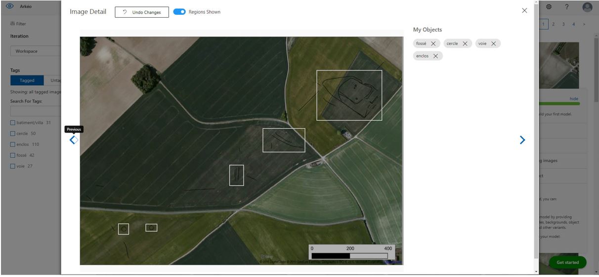
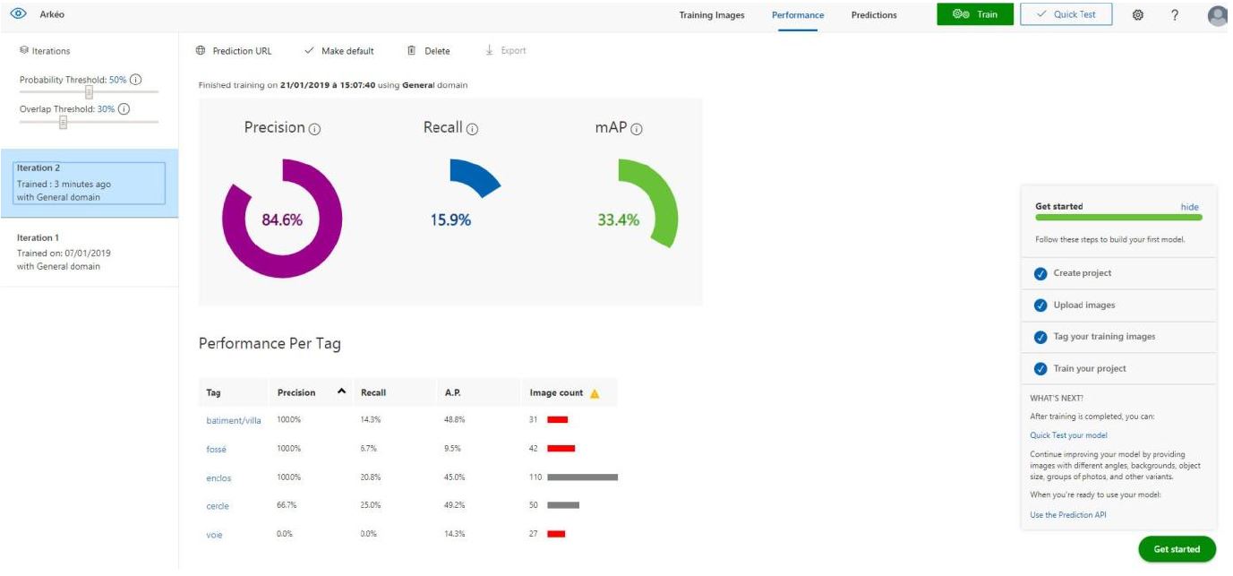
A series of criteria were defined: Roman villa, Roman road, Bronze Age burial circle, Roman buildings, Gallic and Roman ditches. For each criterion, more than a hundred corresponding satellite images have been integrated into the software. The first step was to plot the remains on the satellite images, using image processing software. The results were a perfect systematic identification, without the slightest identification error.
Source: Microsoft
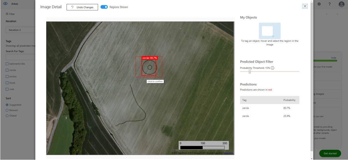
The next phase was to provide new raw satellite images, without the archaeological sites having been redrawn on the image. Then a new iteration was carried out with very positive results, since in all cases the software recognised the visible elements according to the defined criteria.
Source: Microsoft
Excellent results driving a new programme
On the basis of these results, we are setting up a research programme at the University of Picardy, the ARKEO-AI project, which aims to understand the dynamics of settlement of archaeological sites from the end of prehistory to the medieval period in the North of France. The objective is to be able to establish a GIS that will reference as many sites as possible thanks to the Azure Custom Vision software and that will allow researchers to carry out modeling of settlements through the ages. For example, where are the large Roman villas located? Their orientation? On what geological substratum? What types of sites are present on the slopes of the valleys?
This project brings together archaeologists from the TrAme laboratory of the University of Picardy, as well as geographers, geologists and imaging specialists.
The Arkéotéka protocol, which I developed with Sébastien Lermenier, is a unique system for detecting archaeological sites using drones. It will provide new images that will feed the Custom Vision database.
Grey Matter is the EMEA and APAC distributor for Microsoft Bing Maps and has a specialist mapping team who can discuss your use case and advise on the best licensing model. They are also Azure specialists and can get you set up. Contact them directly: mapping@greymatter.com or +44 (0)1364 655133.